Introduction
In the vast realm of satellite imagery, recent advancements have sparked a revolution, opening up new horizons for businesses worldwide. The advent of low-cost satellite imagery services, such as Planet and BlackSky, has transformed the accessibility and availability of high-resolution imagery, empowering businesses of all sizes. Amid this shift, one crucial element stands out: georegistration. In this article, we delve into the significance of georegistration and its profound impact on commercial applications.
Understanding Georegistration
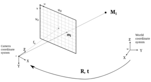
At its core, georegistration is the key that unlocks the true potential of satellite imagery. It is the process of aligning satellite images with real-world geographic coordinates, ensuring accuracy and reliability. Georegistration empowers businesses to extract valuable insights and make informed decisions based on precise spatial data.
The Emergence of Low-Cost Satellite Imagery Services
The rise of low-cost satellite imagery services has paved the way for businesses to harness the power of satellite data. Companies like Planet and BlackSky have democratized access to high-resolution imagery, once reserved for a privileged few. Now, businesses can leverage these affordable services to gain a competitive edge, unlock hidden opportunities, and solve complex challenges.
Leveraging Georegistration for Commercial Applications
Georegistration’s impact extends across various commercial sectors, revolutionizing traditional practices and transforming industries.
In agriculture, georegistered satellite imagery enables precision farming, empowering farmers to monitor crop health, predict yields, and optimize resource allocation. By aligning satellite data with on-ground realities, agriculture undergoes a remarkable transformation, enhancing productivity and sustainability.
Urban planning and development benefit immensely from georegistered imagery. By accurately overlaying satellite images onto urban landscapes, city planners can analyze existing infrastructure, plan future developments, and optimize land use. Georegistration becomes a powerful tool in creating smarter, more efficient cities.
Environmental monitoring and conservation efforts receive a substantial boost with georegistered satellite imagery. From assessing ecosystem health to analyzing climate change impacts, georegistration allows scientists and policymakers to make informed decisions, drive sustainability initiatives, and mitigate environmental risks.
Logistics and supply chain management enter a new era with georegistration. By aligning satellite imagery with transportation networks, businesses optimize route planning, site selection, and inventory management. Georegistration empowers companies to streamline operations, reduce costs, and enhance customer satisfaction.
Overcoming Challenges and Enhancing Georegistration
While georegistration brings numerous benefits, it is not without its challenges. Factors such as cloud cover, data inaccuracies, and processing time can impact the accuracy of georegistered imagery. However, advancements in machine learning algorithms and cloud-based processing offer promising solutions to overcome these obstacles. Continuous improvement in georegistration accuracy is crucial to further enhancing its value in commercial applications.
Future Outlook
The future holds immense possibilities for georegistered satellite imagery. Emerging technologies, such as artificial intelligence, automation, and enhanced data integration, will further augment its impact. Georegistration will continue to shape industries, enabling businesses to make data-driven decisions, seize opportunities, and stay ahead in an increasingly competitive landscape.
Conclusion
Georegistration stands as a transformative force in commercial satellite imagery. With the accessibility of low-cost satellite imagery services like Planet and BlackSky, businesses have unprecedented access to spatial data that can revolutionize their operations. By embracing georegistered imagery, businesses can unlock valuable insights, optimize processes, and make informed decisions to thrive in a rapidly evolving world. The time has come for businesses to harness the power of georegistration and unleash their true potential.