What is Georegistration and why do you need it?
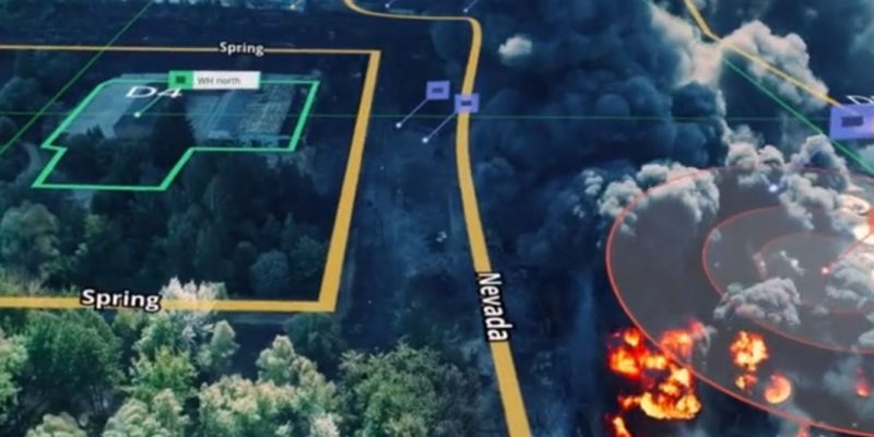
Georegistration is the association of a visual object in an image or a video with an accurate geographical location. In other words, it is the meshing of imagery with the geographical coordinates and landmarks that provides the necessary context to the visual.
The explosion of video footage and sensor data from drones, helicopters, and airplanes has expanded our situational awareness during critical missions such as natural disasters, emergency incidents, and precision military operations.
However, the software tools used to exploit and analyze these video signals struggle to geolocate important information and quickly orient a mission around a particular road or geographic feature. This may be a house threatened by closeby wildfires, a vehicle trapped in a flood area, or a hiker lost in a remote area.
The problem is compounded when the information is needed in real-time to decide where to send a team on the ground or to guide an operation while minimizing collateral damage. The telemetry data from the aerial assets themselves is notoriously inaccurate, and that erroneous information is displayed to pilots and operators, who are making crucial decisions under pressure with life or death consequences.
Georegistration is crucial to make aerial and satellite imagery easier to review, analyze and act upon the information it provides. It can significantly increase the situational awareness of the person reviewing the imagery and reduce disastrous human error. Ultimately, Georegistration is lifesaving technology!
What to look for in a Georegistration solution?
Georegistration for full motion video footage is an emerging technology that is quickly becoming a crucial component of mission critical operations. As such, different solutions vary in capabilities, some of which are detrimental to their viability and effectiveness for the task in hand. The following list should assist you in understanding the critical requirements for GeoRegistaration and guiding the evaluation of a solution.
1. Accuracy
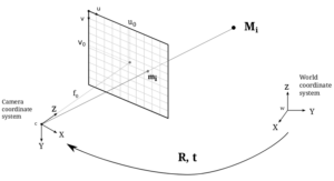
Ideally, the telemetry data received from the aircraft and the camera as part of the video stream should enable accurate Georegistration of the image or video and the relevant points of interest (POI). However, the GIS data from most aircrafts can be off target by as much as 5–20 meters. Camera position (heading, declination, and field of view) could also materially affect Georegistration accuracy.
Depending on the aircraft flight elevation, even a small discrepancy can have a huge effect on the final result. A good Georegistration solution should identify and correct all such errors to provide a position of all objects in the video with a level of accuracy that is down to 1-3 meters.
2. Real-Time Processing
In critical missions, you need to quickly interpret a video and identify the important points of interest. A delay of a few seconds in understanding the incoming imagery can truly mean the difference between life and death. It won’t help to get a 100% accurate Georegistration if it takes minutes or hours for the processing to be completed. For such missions, you need a Georegistration solution that can provide the relevant information in a matter of milliseconds.
3. Electro-optical (EO) and Infrared (IR) Support
The most common type of imagery is electro-optical (EO), which can be most easily understood by humans. However, there are cases where EO is not enough or cannot be retrieved – for example during night time when visibility is limited, or when you need to see through a canopy of trees. In these cases, other types of imagery are used, such as infrared (IR). Your Georegistration solution should support these types of imagery as well as EO.
4. Built-in Augmentation
The ability to GeoRegister is only the first step in providing clear and crisp situational awareness of aerial imagery. Providing additional data layers on top of imagery is important, as is the ability to choose which data layers to present. To enrich the information displayed, advanced users may need the ability to create their own points and areas of interest (POIs and AOIs) on the video and share them with other users.
5. Hardware Agnostic
In very few cases you can rely on images from a single type of platform or sensor. More than likely, you will need to integrate images and videos from various sources. Your Georegistration solution should be agnostic to the specific platform or sensor providing the video and reach the same high level of accuracy and performance on all of them.
6. Open System
When viewing aerial or satellite imagery, there are dozens of different types of data that might be of interest. In many cases, there are systems that already hold data and geographic details of each specific item (e.g. OpenStreetMap that holds the data on roads worldwide). In other cases, you might have your own proprietary data that you’d want to display on top of the imagery. Your Georegistration solution should enable you to easily integrate data from different sources so it can be properly layered and displayed.
Forcing yet another system on users is often costly and a barrier to adoption. To minimize system footprint, training, and migration efforts, you should look for a Georegistration solution that can push its output to your existing systems.
7. No Dependency on Proprietary GIS Data
GIS and mapping services come in many different flavors, providing varying quality of data (e.g. zoom level) at varying costs for different areas of the globe. Depending on your budget and need, you might want to use different mapping services for different scenarios. You may also have a mapping service used by other systems that you would like to use for Georegistration. A Georegistration solution that can support any mapping service rather than require its own proprietary GIS data would be a better match for your needs or budget.
Georegistration is a critical element to attaining situational awareness. Before implementing a solution, start by mapping out your specific needs, and ensure you have the right technology to support each of these seven crucial considerations.


